What areas of Town are considered in the “shoreland zone?”
Land area located within:
- Two hundred fifty feet, horizontal distance, of the normal high water line of any river, saltwater body or the nontidal portion of Goosefare Brook downstream of the Boston and Maine Railroad bridge;
- Two hundred fifty feet, horizontal distance, of the upland edge of a coastal or freshwater wetland. Upland edge of a wetland means the boundary between upland and wetland. For purposes of a coastal wetland, this boundary is the line formed by the landward limits of the salt tolerant vegetation and/or the maximum spring tide level, including all areas affected by tidal action. For purposes of a freshwater wetland, the upland edge is formed where the soils are not saturated for a duration sufficient to support wetland vegetation; or where the soils support the growth of wetland vegetation, but such vegetation is dominated by woody stems that are six meters (approximately 20-foot) tall or taller.
- One hundred feet, horizontal distance, of the normal high water line of the nontidal portion of Goosefare Brook upstream of the Boston and Maine Railroad bridge; or
- One hundred feet, horizontal distance, of the normal high water line of a stream;
- In addition, the shoreland zone extends seaward to the municipal boundary.
What does it mean if my property is located within 100 feet of the Highest Annual Tide (HAT)?
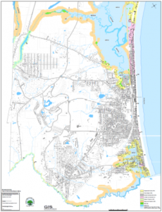
If you look at the shoreland zoning map attached below, you’ll see several areas in blue that say HAT 6.3. This is especially true for properties located in Ocean Park. So what does this mean if I want to expand or relocate a structure that’s located within the HAT?
If a project is within a Shoreland Zone and if it is within 100 feet of the HAT it is considered a nonconforming structure. Because of this, it requires Planning Board (PB) review as a Conditional Use and Shoreland Nonconforming Structure Expansion/Relocation. You might think this is odd because typically shoreland zoning applies when a property is within 250 feet of a waterbody. However, the Town took the State Shoreland Zoning rules a step further and applied their own rules to areas that fall within the Highest Annual Tide of 6.3 feet. This approach was part of the town’s efforts to prepare for sea level rise.
Because the structure is nonconforming, the existing floor area or volume cannot increase by more than 30%. Floor area is the square footage of all floors, porches, and decks. Volume is the space within a roof and fixed exterior walls. A new or replacement basement is not included in the 30% calculations if it does not extend past the exterior dimensions of the structure and does not raise the structure by more than three feet.
The PB will also look to see that the structure is relocated away from the “water” (HAT) to the greatest extent possible. Shoreland standards seek to make nonconforming structures as conforming as possible so one standard requires nonconforming structures to be moved as far away from the water as possible.
To obtain a copy of the required application materials and to prepare your proposal for the Planning Board, please email Planning Staff for assistance.
| Attachment | Size |
| Shoreland Zoning Map | 5.16 MB |